Kokosing Construction Company works with Identified Technologies to cut costs while moving mountains in Kentucky
Pittsburgh, PA – September 19th, 2017 – Identified Technologies, the leading provider of automatic drone mapping and tracking for construction and energy job sites, announced today a partnership with Kokosing Construction Company. This partnership reduced cost and increased efficiency on a multi-million dollar Kentucky highway project.
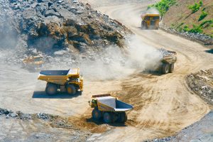
On these projects, Kokosing needed to survey two, 500-acre sites to track their progress and profitability as they cut through five mountains and used the rock aggregate for fill. Identified Technologies’ fully-managed commercial drone solution was able to provide fully integrated mapping and tracking, giving Kokosing total control of its job site data.
Kokosing Construction Company moving earth in Kentucky
Located in Elkhorn City, Kentucky, the two sites combined for a total of 1,000 acres. Both were drone mapped in less than a half-day, and Kokosing was easily able to track the 33 million cubic yards of rock moved throughout the projects. Kokosing Construction was able to defer project survey related costs by using Identified. “The combination of precision, 200 times faster speed, reduced cost, and increased safety, checked every box for us,” said Bill Clifford, Head Surveyor, Kokosing Construction.
Dick Zhang, CEO of Identified Technologies commented: “Generally, clients see survey savings of 80%-90% on their projects, thanks to the increased speed and accuracy of their mapping data.”