08 Apr 4 Reasons Why Mapping Drones are a Land Surveyor’s Best Friend
Mapping Drones For Surveyors
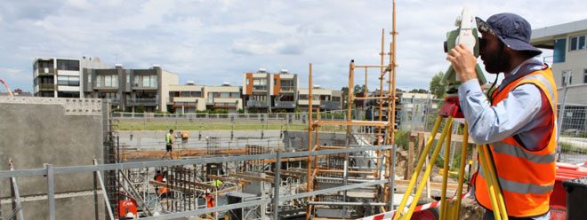
Carpenters use electric drills; accountants use calculators; surveyors use theodolites, infrared reflectors, GPS, and more. However, mapping drones might be changing how land surveyors conduct surveys from the sky instead of by land.
There are several reasons for this, the main one being the fact that data captured via drone mapping perfectly complements what engineers can see from the ground.
- Safety of Employees: Though land surveyors are paid above the national average, their work does not always consider weather conditions or physical fatigue. Land surveyors’ work is always outdoors regardless of weather and consists of a lot of stamina and potentially long commutes. There is also an additional danger of tough or unexpected terrain. Having a drone mapping solution allows for autonomous flights eliminates several risks associated with land surveying such as heavy equipment and hazardous injuries. With the push of a button, a drone can autonomously survey a site, obtain a complete aerial mapping of the site, land back at its launch location, and upload its model and data to a secure cloud in a matter of minutes. Plus, this entire process does not put anyone at risk of serious injury.
- Survey Speed: When it comes to speed, there’s no comparison between drone mapping and land surveying. Land surveying requires long hours and carrying heavy equipment from one location to another. Instead of days or weeks, drone mapping takes minutes to complete a site survey with the same amount of accuracy as you would on foot. Drone mapping makes it possible for ad hoc flights of entire sites or specific areas of projects to gain easy access to the most up-to-date information on a site on regular basis.
- Project Budget: Budget – everyone’s favorite word. The ability to make efficient use of a budget is at the forefront of most folks’ minds. The beauty of drone technology is you most likely already have the budget. Drone mapping can fit seamlessly into your pre-existing budget allocations and can also increase company budget and time to spend on other tasks. A traditional ground survey team may need a month to map a dangerous 100-acre site, but a mapping drone can complete the same task in less than half an hour. The increased speed and automation that drone mapping provides permit companies to safely take on and complete more jobs for more clients, on more sites, in less time.
- Single Tool: Instead of theodolites, infrared reflectors, and GPS, land surveyors can now use drones that autonomously pilot with the push of a button. These drones are capable of producing equivalent results as the aforementioned tools without all of the heavy-lifting and exhaustion. This would in turn allow the surveyors to be safer, spend less time on each site trip, and save or re-budget money.
Related Content: How Engineering Firms Grow Using Drone Mapping
Though there are tools that have traditionally been used for land surveying, it may be time to give them an upgrade – to drones. With some budget refactoring to allow for no additional cost, the use of drones would allow land surveyors to obtain data just as accurate as before but in a safer, more manageable, and time-efficient manner.

Scott Adams
Posted at 16:07h, 01 NovemberIt’s interesting that you talked about how a drone will only take minutes to map an entire area. I have been thinking about becoming a land surveyor. I can see how it would be nice to have a drone available, so I don’t have to spend as much time walking around.