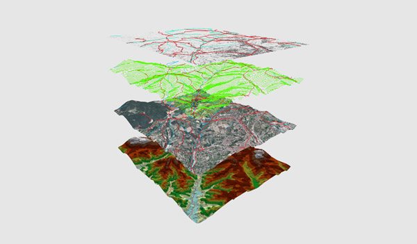
On June 15th, 2016, the U.S. Open was held at the Oakmont Country Club in Plum, Pennsylvania. But, the renowned golf competition’s annual journey did not begin there. On a cold October morning in 2015, a single survey drone initiated its mission. Flying over all 7,255 yards of Pennsylvania greens, the drone tracked, mapped, and planned the location that would soon host the world’s best golfers....

Is your company debating between building an in-house drone solution or subscribing to a commercial drone solution? If so, there are several items to think about, most of which come back to the question of if it is worth it to retain all ownership, power, and accountability, or to have a commercial drone solution help shoulder some responsibility and provide expert knowledge and software....

Time is money. Waiting weeks or months to receive mapping information for rapidly changing job site causes bad data, delays, excessive labor costs, and unhappy customers. Traditional mapping methods such as a manned helicopter or fixed-wing plane or a ground survey team often takes 1-2 months to gather and process the data into a report. By the time you receive it, the data is already old, inaccurate, and misleading....

The search for faster and more affordable aerial topographical mapping has long been the “Holy Grail” for industries ranging from construction to mining to energy. Small, low altitude aerial surveying drones have shown the flexibility and reliability to be the ideal way to produce a map, drawing, measurement or a 3D model of any type of terrain. ...